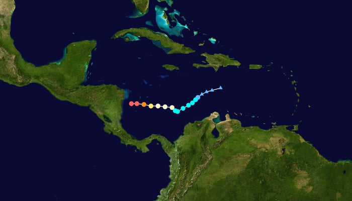
As Hurricane Iota develops into a category 5 monster, Nicaragua, Honduras, and elsewhere braces for impact.
It hasn’t made landfall yet and Hurricane Iota is already breaking records. This storm is the strongest hurricane of 2020 and the latest calendar-year hurricane on record.
None of this matters to the people of Bilwi (Puerto Cabezas) and elsewhere on Nicaragua‘s Caribbean coast. They’re still cleaning up after the Category 4 Eta hit two weeks ago. And now they have this all over again.
? 2:50 PM | Nuevo Jerusalén uno de los barrio más vulnerable en #Bilwi así se encuentra en este momento. pic.twitter.com/gdejdK69gk
— NicaraguaActual (@NicaraguaActual) November 16, 2020
The US-based National Hurricane Center summarized Iota as a “life-threatening situation”.
Catastrophic wind will wreak even more damage on Bilwi and its surrounds, says the National Hurricane Center. It’s already started. This area can also expect a major storm surge, with water levels up some 15-20 feet. Massive waves will also hit the coast.
One commenter, in a piece of black humor, said the only reason this storm won’t cause so much damage is because Eta already destroyed it all.
Hurricane Iota is moving towards Nicaragua at a speed of 15 km per hour, throwing up winds of over 200 km/h. It’s expected to make landfall sometime tonight. Then it’ll weaken into a tropical storm, as it heads inland, dumping massive amounts of rain. All this onto ground already saturated by Eta.
Honduras, northern Nicaragua, southeast Guatemala, and southern Belize can expect 10 to 20 inches of rain, with the possibility of up to 30 inches in some areas.
4 PM EST Mon, Nov 16 #Iota Key Messages: Category 5 Hurricane #Iota is expected to produce extreme winds & life-threatening storm surge along portions of the coast of northeastern Nicaragua, along with life-threatening flash flooding in Central America. https://t.co/tW4KeFW0gB pic.twitter.com/3grGFofvTr
— National Hurricane Center (@NHC_Atlantic) November 16, 2020
CONRED, Guatemala’s disaster relief agency, recommends those living near rivers evacuate as soon as they can.
“The expected rains will cause an increase in the rivers that make up the Motagua, Polochic, Chixoy, Usumacinta, La Pasión Río Paz basins. Soil saturation can also cause landslides, landslides and damage to the country’s road network,” said CONRED.
After landfall in Nicaragua; Honduras and Guatemala will feel immediate effects of the storm. Tomorrow will be rough in all three countries, plus southern Belize. Then, by Wednesday, it will be El Salvador‘s turn as the Iota settles over that country as a tropical storm or depression.
Es de suma importancia que cada miembro de su familia cuente con una mochila de las 72 horas.
Tome en cuenta las siguientes recomendaciones: pic.twitter.com/puijTNECVF
— CONRED (@ConredGuatemala) November 16, 2020
Parts of Costa Rica also expect heavy rains in the coming days, although the storm won’t directly hit.
Nonetheless, rain is expected (on, again, already saturated ground) on Costa Rica‘s Central and Southern Pacific zones, plus the Central Valley.
Panama‘s Darien Province is already reeling from earlier flooding brought by Iota, while Chiriqui Province expects to receive more rain.
Worryingly, after Iota, experts see another pattern forming in the Caribbean which they say has a 40% chance of developing into something.
ANOTHER area of disturbed weather in the Caribbean behind Iota. This one has a 40% chance of development over the next 5 days. Extended models show this crossing over Costa Rica or Panama and potentially getting stronger in the Pacific. We will keep tracking it. #Storm11 pic.twitter.com/3PRRkvc1Qx
— ChrisHolcomb11Alive (@ChrisHolcomb) November 16, 2020
James Dyde is the editor of www.centralamerica.com. He lives in Escazu, Costa Rica.


